Samsung Weather App Sparks Controversy Over North Korea Territory Labeling
## Introduction
Global technology companies are increasingly finding themselves caught in geopolitical disputes, and now Samsung is facing criticism after users noticed a controversial labeling issue within its weather application. The incident sparked intense online debate after the app allegedly displayed disputed territories in a manner that appeared to favor North Korea’s territorial claims.
The controversy quickly gained traction across social media platforms, with users accusing the company of political insensitivity and poor oversight. As digital maps and location-based services become central to everyday technology, even seemingly small geographic inaccuracies can create major diplomatic and reputational challenges.
For cybersecurity and digital trust experts, the situation highlights a growing concern: how software platforms handle geopolitical data and the security implications of digital mapping systems.
## What Happened?
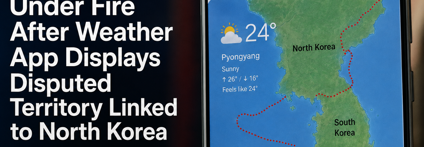
Reports surfaced after users observed that Samsung’s weather app identified a disputed maritime territory in a way that many interpreted as aligning with North Korean perspectives. Screenshots circulated online, triggering backlash from South Korean users and international observers alike.
Although the weather app itself is designed primarily for forecasting and regional climate updates, it relies heavily on integrated mapping systems and third-party geographic databases. These systems determine how borders, regions, and territorial names appear to users in different countries.
Critics argued that the app’s presentation could unintentionally legitimize sensitive territorial narratives, especially in a region where geopolitical tensions remain high.
Samsung has not publicly confirmed whether the issue resulted from internal mapping configurations, localization settings, or external data providers. However, the company reportedly began reviewing the complaints soon after they gained public attention.
## Why Digital Maps Create Political Risks
Technology companies frequently face pressure when displaying borders, territorial claims, or regional names. Different governments often require platforms to present maps differently depending on local laws and political positions.
Major companies including Google, Apple, and Microsoft have previously encountered similar disputes involving regions such as Crimea, Taiwan, Kashmir, and the South China Sea.
For multinational apps, the challenge becomes balancing:
- ▸Local legal compliance
- ▸International neutrality
- ▸User trust
- ▸Political sensitivities
- ▸Data accuracy
Even weather apps are not immune because they rely on location intelligence systems that combine:
- ▸GPS data
- ▸Geospatial databases
- ▸Mapping APIs
- ▸Regional localization engines
- ▸Government-approved territorial datasets
A minor configuration difference can therefore trigger major controversy.
## The Cybersecurity Angle Behind Mapping Controversies
While the issue appears political on the surface, cybersecurity professionals warn that manipulated or inaccurate geographic data can also introduce broader security concerns.
1. Data Integrity Risks
Digital maps are only as trustworthy as the databases powering them. If mapping systems are altered, compromised, or manipulated, users may receive misleading geographic information.
In cybersecurity, maintaining data integrity is critical because inaccurate location data can impact:
- ▸Navigation systems
- ▸Emergency response coordination
- ▸Military intelligence
- ▸Supply chain logistics
- ▸Telecommunications infrastructure
2. Supply Chain Vulnerabilities
Many mobile applications depend on third-party APIs and external geographic services. If a vendor’s data source becomes compromised, incorrect territorial information could spread across multiple platforms simultaneously.
This creates a potential software supply chain issue, where a single data provider affects millions of downstream users.
3. Information Warfare Concerns
Geopolitical narratives increasingly play a role in cyber and information warfare. Governments and threat actors may attempt to influence digital ecosystems by shaping how territories, regions, or political boundaries appear online.
Security researchers have repeatedly warned that digital cartography can become part of larger disinformation campaigns.
## Public Reaction and Online Backlash
The controversy generated significant reactions across online communities. Many users accused Samsung of failing to properly review regional sensitivities before deploying updates to its application ecosystem.
Some social media users called for:
- ▸Immediate correction of the mapping issue
- ▸Greater transparency from Samsung
- ▸Independent review of geographic datasets
- ▸Improved localization oversight
Others argued that the incident may simply reflect automated map rendering behavior rather than deliberate political positioning.
Regardless of intent, the situation demonstrates how quickly trust issues can emerge when technology platforms appear to mishandle geopolitical content.
## Samsung’s Reputation Challenges
As one of the world’s largest smartphone manufacturers, Samsung operates in highly sensitive global markets. Any controversy involving political neutrality or territorial disputes can affect:
- ▸Brand reputation
- ▸Government relationships
- ▸Consumer trust
- ▸International partnerships
The company already operates under intense scrutiny due to its dominant role in:
- ▸Mobile devices
- ▸Semiconductor manufacturing
- ▸Telecommunications equipment
- ▸Smart ecosystems
- ▸AI-powered services
Because millions of users depend on Samsung’s applications daily, even small errors can rapidly escalate into global discussions.
## The Bigger Problem for Global Tech Platforms
This incident reflects a broader issue facing international technology companies: digital products are no longer politically neutral.
Apps that use:
- ▸Maps
- ▸AI-generated location systems
- ▸Satellite data
- ▸Language localization
- ▸Regional recommendations
must constantly navigate geopolitical complexities.
As artificial intelligence becomes more integrated into mapping and automated content generation, experts warn that such controversies may become more frequent.
AI-driven systems can unintentionally reproduce biased or disputed geographic information if training data or regional settings are inconsistent.
## How Companies Can Reduce Similar Risks
Cybersecurity and digital governance experts recommend several strategies to reduce geopolitical mapping controversies:
Stronger Data Validation
Companies should verify geographic information using multiple trusted sources before deployment.
Regional Compliance Audits
Applications should undergo region-specific testing to identify politically sensitive labeling issues.
Human Oversight for AI Systems
Automated mapping systems should include human review mechanisms for disputed territories.
Transparent Correction Policies
Technology firms should respond quickly and transparently when users report geographic inaccuracies.
Secure Supply Chain Monitoring
Organizations must monitor third-party mapping vendors and API providers for data integrity risks.
## Conclusion
The Samsung weather app controversy may appear minor at first glance, but it underscores a growing reality in the digital age: even everyday applications can become entangled in geopolitics, cybersecurity concerns, and public trust issues.
As global technology platforms increasingly rely on automated geographic systems, companies face mounting pressure to ensure accuracy, neutrality, and transparency.
For users, the incident serves as a reminder that digital maps are not merely technical tools — they are powerful representations of political, cultural, and territorial narratives that can influence public perception worldwide.
In an era shaped by AI, cyber threats, and information warfare, the integrity of digital geography may become more important than ever before.
Read More:
The Mythos Stress Test: Are Indian Banks & Fintechs Ready for AI-Native Cyber Threats?
India Lost ₹52,000 Crore to Cyber Frauds in 5 Years – Govt Tightens Telecom Security
₹152 Crore Cyber Scam Exposed Across 14 States – How Mule Accounts Fueled Massive Fraud
First Public macOS Kernel Exploit on Apple M5 Developed Using Mythos Preview in Just Five Days
SEBI Creates AI Cyber Defense Task Force to Protect India’s Financial Markets
Cybersecurity Agencies Warn Users Against New Digital Fraud Tactics
## Analyst Commentary & Implementation Blueprint
Security advisory
Continuous security exposure assessment is critical to identifying public vulnerabilities before they are exploited. Organizations should maintain a passive inventory of all web servers, TLS configs, and open ports, ensuring that default configurations are eliminated and security advisories are actively implemented.
Hardened Security Configuration Blueprint
# General Security Hardening Directive
ServerTokens ProductOnly
ServerSignature Off
FileETag None
Actionable Mitigation Checklist
- ✔Perform passive asset inventories weekly.
- ✔Restrict administrative ports using local firewall controls.
- ✔Monitor active CVE alerts for exposed software.
Common Inquiries & FAQs
Why is passive scanning preferred for continuous auditing?
Passive audits do not cause operational impact or trigger firewall blocks, making them ideal for constant surveillance of internet-facing assets.
What should I do if a vulnerability is flagged?
Apply the latest vendor patches, restrict access to the resource via firewalls, or verify configuration flags to mitigate risks.
Surendra Reddy
Surendra Reddy is a cybersecurity researcher and founder of ReconShield, specializing in OSINT and defensive infrastructure analysis.
Connect on LinkedIn ↗// AUDIT BRIEFING DISCUSSION (2 COMMENTS)
Great breakdown of the passive infrastructure vectors. We recently audited our external DNS zones and found multiple dangling staging environments. Implementing wildcard certificates reduced our CT log leaks significantly.
Is there any automated tooling you recommend for daily crt.sh scraping? Manually checking CT logs is becoming unsustainable for our domain portfolio.
// MORE ARTICLES

Security Researchers Warn Critical n8n Flaws May Expose Automation Platforms to RCE
Researchers have disclosed critical vulnerabilities in n8n that could expose automation workflows and connected enterprise systems to remote code execution risks, prompting urgent patch recommendations for users and administrators.

How Agentic AI Is Changing Software Engineering and Expanding Mobile Attack Surfaces
Agentic AI is rapidly transforming software engineering workflows through automation and intelligent coding assistance, while cybersecurity experts warn of expanding mobile attack surfaces and emerging application security risks.
Massive Temu Data Leak Claim Emerges: 310 Million Accounts Allegedly Exposed
Temu data leak claim: 310 million accounts allegedly exposed. See what's confirmed vs unverified, what data is at risk, and the steps every user should take now.